
Previous Pu`u `O`o Eruption Episodes of Kilauea Volcano
(Detailed info about Episode 55 - Pu'u O'o Crater)
One Fine Daybreak at the Puu Oo cone

This page contains update information from Episode 55 of the Pu'u O'o eruption of Kilauea Volcano 24 Feb 1997 to Dec 2005 (updates discountinued after this time)
Please see the eruption update page or the
HVO website for a more recentactivity summary
NOTE: HCV had been posting detailed eruption updates in the 1990s before WWW capability was established at HVO on the Big Island. HCV discontinued these detailed updates, such as you will read below, in late 1999, with very limited updates provided thereafter
|
Episode 55 of Pu`u `O`o eruption started on 24 Feb 1997. The USGS Hawaiian Volcano Observatory
(HVO) has identied each distinct
phase of the Pu`u `O`o eruption with an episode number; For a summary of
previous episodes, see our
compilation.
This latest phase of eruptive activity at Kilauea volcano started unceremoniously on 24 Feb with the appearance
of a small amount of molten lava deep within the Pu`u `O`o crater, visible only from above. Yet the ensuing 9 years have seen multiple spectactular periods of eruptive activity. The first couple of years of activity are detailed on our episode 55 page.
PLEASE NOTE: HCV discontinued making detailed eruption updates in late 1999, once web capability was established at HVO.
Synopsis of events
1997 through 1998 saw increased activity, a resumption of the ocean entry, lava bench formation and collapse (at the seashore), crater overflows and a general collapse of the large main crater cone bulit in priot episodes of the eruption.
1999 through 2001 saw continue eruptions from a crater flank vent, lava flows exiting the National Park on the East Flank and new ocean entries.
2002 and 2003 saw a shift of activity from the coast to upslope, with new surface flows and associated activity
2004 and 2005 saw resumption of vigorous ocean entries, including a new addition to the wester margin of the flow field. Activity upslope also continued, off and on, through the period.
some more details
Episode 55 arrived after a 24 day-long
hiatus in eruptive activity. This hiatus in turn followed
a brief but spectacular fissure eruption (Episode 54) at
Napau Crater in late January 1997.
This last long hiatus had many volcano watchers presuming that the multi-year
Pu`u `O`o eruption was finally Pau (Pau in Hawaiian means over,
or finished). This is because long hiatuses have not occurred during
the last decade at Pu`u `O`o (the last long one was in mid-1986, when
volcanism switched from episodic, 300-500m high, fire fountains of lava
to continuous effusion).
Episode 55 has seen shifting vent locations on flanks of Pu`u `O`o cone and a
build up of the lava shield mostly on the south flank of the Pu`u `O`o
cone. The lava pond within the Pu`u `O`o crater has intermittently risen
to produce flows on its east and west margins as well.
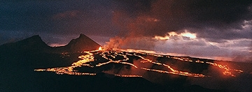
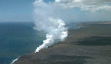
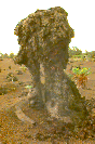
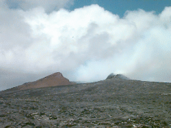
The lava shield is the low bulge beneath the cone in the photo at the top of
the page (taken on 26 May 1997).
Surface volcanic activity was extremely limited in the
early days of Episode 55, occurring only deep within the Pu`u `O`o crater.
On 28 March 1997, the lava level in the Pu`u `O`o crater rose and began feeding
the subterreanean channels ("lava tubes") that fed small cones just
south of the cone. Lava began erupting from several of these cones,
enlarging the lava shield formed over the past 16 years.
In early July of 1997, lava began flowing down toward the coast, resulting in a
resumption of ocean entry on July 12 near the eastern edge of the national
park. This was the first time since January that surface flows at Kilauea
reached the sea; prior to that, episode 55 had been restricted mostly to
the area around the Pu`u `O`o cone at elevations over 2000 feet. Between 29
July and 4 Aug the lava-sea entry had temporarily ceased, but restarted and on 11 Aug
a lava flow overran a 700 year-old Hawaiian temple ("Waha'ula heiau"),
almost completely obscuring the ancient rock walled structure.
Additionally, lava from within the Pu`u `O`o lava lake has risen
high enough to have spilled out of the crater within the Pu`u `O`o cone and
over the side at least twice in the past month.
Between early August and October 1997, the volcano experienced a number
of lava overflows
from the Pu`u `O`o crater, which initiate with molten lava ponding in
the crater until it spills over the rim, issuing rivulets of lava to the
east and west of the crater. Although spectacular, these particular flows
have yet to reach more than about 0.7 km from the crater. The lava that is
feeding the ocean entries issues from vents just outside of the Pu`u `O`o
cone into lava tubes that run to the coast. These tubes experience
occasional short-lived breakouts where lava flows on the surface. Otherwise,
surface activity is typically very limited in locations away from the
Pu`u `O`o vents.
|
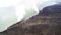
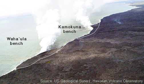
Both ocean entries have repeatedly formed lava benches, where new land
is building out beyond the former seacliffs. Some or all of these unstable
land masses have repeatedly collapsed into the sea. An example of what
the benches looked like as of October 1997 is in the image to
the left (outlined by white lines). Early in November 1997, one of the two
lava benches suffered a large collapsed into the sea, taking some 4.75
acres of new landscape with it. Later, lava from the same tube system
rebuilt a shelf at the foot of the cliffs formed during the collapse.
Additional large collapses have occurred, such as on 15 January and
between 16 and 19 February, 1998.
|
|
|
These episode 55 photos of the two active benches (posted 3 and 18 Nov 97)
can be viewed at the
USGS-HVO
web site or by clicking on the small versions
to the left. (images Courtesy of the USGS-HVO)
|
|
The cliffs formed during the 18 Nov. collapse can be seen in the lower
small photo to the left. This latest collapse illustrates that lava
benches form and then collapse at unpredictable intervals. HVO warns visitors
that "these benches can collapse into the sea without warning, triggering
steam explosions that hurl dense rock and molten spatter tens of meters
inland. No one should venture onto the benches, no matter how
stable the new land may appear."
|
|
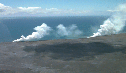
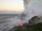
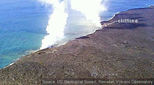
Additionally, the photos (to the right) are of the two active
sea entries as they appeared in late March of 1998.
Click on the images to view full size (photos by Ken Rubin)
|
In mid Jan 1998, there was a breif surge in activity at Kilauea, wherein
a lava intrusion caused rapid inflation of the summit, followed by defaltion.
A summit eruption did not occur. Rather, the lava appeared to have entered
the East Rift Zone and caused enhanced activity at the Pu`u `O`o vent
(17 km to the east) and an increase in surface flow activity at points
between Pu`u `O`o and the coast. The earthquakes and magma surge disrupted
the steady-state pattern of activity that has characterized most of the past
6 months of the eruption. This latest disruption subsided in (Feb. 1998)
and the eruption is returned to a pattern more typical of
previous months.
By Feb 1998 the eruption had settled into a routine of fairly
steady magma supply to the Pu`u `O`o crater and the sea entries
near the coast. A number of additional bench collapses, brief
eruption hiatuses and surface flow breakout episodes have also occurred,
as well as a short period of enhance lava-lake activity at the crater
in May 1998 that did not affect the overall effusion rate at the ocean entries.
In early July, one of the two ocean entries that have been active
for most of Episode 55 (the Wah`aula entry) died but the other remained active.
1999 through 2001 saw continue eruptions from a crater flank vent. There was a brief hiatus in eruptive activity during a new intrusion of magma on the East Rift Zone, closer to the Kilauea caldera (Sept 1999) but activity resumed a week and a half later with spectacular surface flows, that made it to the sea by December of that year. Flows exited the park in early 2000 and for the next couple of years overran five abandoned houses in Royal Gardens subdivision (thus increasing to 189 the total number of structures destroyed by this eruption). A new ocean entry began on the eastern edge of Kupapa`u, marking the first ocean entry outside the national park since 1991.
In early 2002 tube flow slowed and ocean entries stopped. Breakouts occured higher upslope and by march had created a nearly 3km long ridge of lava shields above 2000 ft. elevation. Crater activity also picked up and fed new flows into Royal Gardens. By Mother's Day, another flow (this time on the western edge of the flow field) issued from a flank vent on the west of Puu Oo and entered forested lands and took over most of the lava supply from the other parts of the flow. It reach the sea in July 2002 and continued for the next year. A second breakout from this same lava tube sent a new flow seaward in early 2003 for a few weeks. By later in the year,
activity had diminished near the coast activity shifted upslope again as surface flows and spatter cones.
Jan 2004 saw resumption of flows directly from the crater for the first time since 1998 and activity there continued through March 2004. A flow named for Martin Luther King Day (the MLK flow) began during this period. A second breakout occured on Prince Kuhio Day in March, producing what HVO calls the "PKK" flow. It was the main flow through by Aug 2004, and continued through 2005, with ocean entries from two branches begining in Nov 2004 and June 2005. This became the dominant tube by August 2004. The Mother's day tube also once again began producing "rootless" shields in early 2004, producing a flow that entered the sea from May to July 2004. Activity resumed in and around Pu`u `O`o crater in Jan 2005, with spattering through Feb. 2005 and the formation of sevaral small lava ponds. The PKK flow remained active through Dec 2005. Activity remains intermittent as well on the MLK flow.
Feb 1997 - Sept 1999: LAVA FOUNTAINING, EFFUSION AND THEN SEA ENTRY RESTART, SPECTACULAR CRATER OVERFLOWS, CONTINUED ERUPTION FROM FLANK VENTS
12 Sept 1999
HVO reported a swarm of earthquakes today located on the East
Rift Zone of Kilauea near Mauna Ulu (which is between Puu Oo and
the Kilauea summit). The largest quake was about 3.7 in magnitude.
Lava entry into the sea has dropped of to a trickle and the floor of
the Puu Oo crater has sunken in and is now filled with rubble.
More details will be posted as they are available.
There is a gap in time in the updates because the page aughor has
been mostly out of the country during this time. It will be filled
in soon...
13 Mar 1999
UH Researchers Scott Rowland and Peter Mouginis-Mark posted
this informative update
of the eruption status. It includes some beautiful pictures of
activity at the lava ocean entry that results in the formation
of "littoral cones".
Jan - Feb 1999: Missing updates will be added soon!
1 Nov - 16 Dec 1998
A brief pause in the eruption on November 11 led to several
small `a`a and pahoehoe
flows on the coastal plain that didn't reach the sea. In the past several weeks,
HVO staff have measured a slight increase in lava discharge to the tube
system: from less than 300,000 m3/day in October to just over
400,000 m3/day in early December. Dense volcanic fume continues to
obscure various pits within Pu`u `O`o most of the time, but
sloshing sounds of lava degassing can be heard from the crater rim.
A major bench collapse occured sometime around 10-11 Dec. It removed
not only new land built since August 1998, but also a part
of older shoreline built by lava flows between 1992 and 1997
A new pit that had developed on the south flank of Pu`u `O`o vent about one year
ago recently enlarged significantly by slumping of its walls into the pit. The
pit (aka "pukanui" crater) was 50 m in diameter at the surface and about 50 m
deep on 9 Dec 1997. It enlarged to 150-180 m in diameter by 11 Nov 1998 and has
consumed part of the shield at the base of Pu`u `O`o that is constructed of lava
flows. Interestingly, the pit is becoming shallower as more debris slumps
in from its walls.
24 - 29 Oct 1998
HVO reports that a red glow has been visible in steam cloud above Pu`u `O`o
on several occasions during the past week. The vent had been mostly obscured
by clouds and volcanic fume for many weeks (thus this glow is not from a change
in the eruptive activity). Breakouts and surface flows have been limited in
number but lava continues to enter the ocean at two localities west of Kamokuna.
The East Kamokuna has stopped flowing into the ocean.
11 - 23 Oct 1998
Lava from the Pu`u `O`o eruption continues to reach the sea via both small,
intermittent surface flows and a new lava tube that developed on the
coastal plane in August. For instance, a new pahoehoe surface flow
issued from a lava-tube skylight near the base of the pali on 9 Oct.
and moved toward the coast, reaching the sea on 19 Oct. A 150 m wide
lava bench has grown at the Kamokuna coastal entry, although a small
A new skylight formed at about 635 m elevation on 20 Oct. above the lava tube
supplying the coastal plane. Lava moving through the tube is a
relatively deep 7-9 m below the surface. This particular tube formed
in August 1997. Up at the main vent, Dense volcanic fume from Pu`u `O`o
has obscured views into the crater for the past several weeks. Lava has
not been seen in the crater for months.
11 - 28 Sep 1998
The eruption continued in routine fashion over the past 2 weeks.
A small part of the eastern most bench at the Kamokuna coastal entry
slid into the sea on 22 Sept. Additionally, HVO reported that a number
of earthquakes occured in and around Kilauea during the period, including
magnitude 4.6 and 4.1 quakes on September 27 and 28 (epicenters located
near the volcano) and a magnitude 4.8 quake on September 28 (epicenter
located about 18 km southeast of the volcano). None of these earthquakes
affected the eruption. Reports indicate that damage to property and
injuries related to the quakes were limited.
5 - 10 Sep 1998
New surface flows continue to spill over the sea cliff 300 m
(1000 ft) west of the east Kamokuna entry (5 km from the end of the Chain of
Craters Road). These new flows began 14 Aug.
but didn't reach the ocean until 30 Aug. This new entry
has added a narrow swatch of land about 500 m (1600 ft)
by 80 m (250 ft) wide. A small flow also
entered the sea east of the east Kamokuna entry on 5 Sept. but
stagnated the next day.
The flows feeding the new entry are fed by tube
system that originates at Pu`u `O`o. This tube
broke open and spawned the new surface
flows from a point at the 365-m (1200-ft) elevation of Pulama pali. About
half of the tube's discharge was shunted into the surface flows, while the
other half continued to move underground down the tube to the east Kamokuna
entry. The vigor of the plume at east Kamokuna has declined these past few
weeks, reflecting the diminished entry.
The pattern of recent events, from formation of a new surface flow, to a
lava tube feeding the ocean, is relatively typical of recent phases
of the Pu`u `O`o eruption.
When young, the active lava flows were mostly molten.
Upon cooling, the there were fewer molten parts
focussed into relatively narrow conduits that
carred much of the lava. When the channels roofed over,
new tubes were born. The most favorably situated conduits get
most of the new magma. The others slowly congealed.
25 Aug - 4 Sep 1998
On 25 Aug., a new surface pahoehoe flow formed at the base of the pali
(scarp) between Pu`u `O`o and the coastal flat.
The flow front was initially about 500 m from the shoreline and reached the
sea on 30 Aug. It joined the previously active Kamokuna ocean entry.
Before entering the sea, lava at the new entry intially poured over a
sea cliff created by a previous bench collapse and onto a black sand beach.
HVO reports that as of 4 Sep., the
broad, slowly inflating flow is developing a new lava tube within the flow
as molten lava becomes channeled and the upper surface cools
to form the new tube "roof". Since many small pahoehoe toes have formed
along the margins of the new flow (upslope from the shoreline), the area
is particularly hot and HVO cautions that the approach from the end of the
Chain of Craters Road in Hawai`i Volcanoes National Park) is difficult and
hazardous.
HVO also reports the partial collapse of the walls of the Episode 55
spatter cone (near the west flank of Pu`u `O`o itself) on 26 Aug.
Seismologists had first observed a series of low frequency seismic signals
generated in the area and then HVO field workers confirmed on 27 Aug
that a notch had formed at the rim of the spatter cone. By 3 Sep.,
the notch had grown into a crater that was about 50 m in diameter.
15 - 20 Aug 1998
Shortly after eruption pause that ended on 14 Aug, surface flows were
seen flowing over the pali toward the ocean. In all, HVO detected 5
different short-lived lobes of surface flowage.
The surface flows ignited small brush fires but posed
no threat to structures in the area. By later in the
week, the pre-hiatus lava tube system leading to the ocean at Kamokuna
was reoccupied by lava and it flowed underground to the sea.
7 - 14 Aug 1998
This period has seen mostly constant lava effusion from the
Pu`u `O`o vent. However, there was a 42-hour hiatus in the eruption
on August 12-14. Like the pause in mid-July (see below),
it ended with substantial surface flows breaking out of the lava tubes
on the Pulama Pali and coastal flat. This was the 20th pause of episode 55.
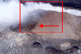
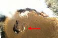
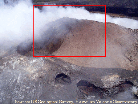
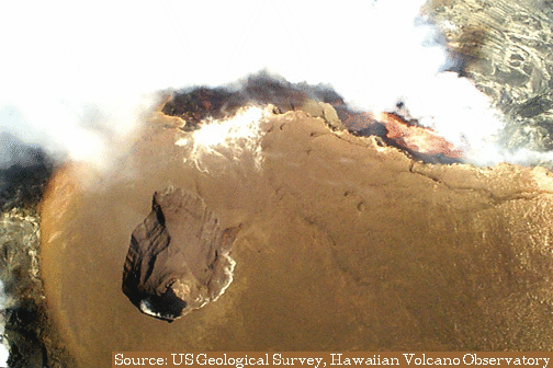
Additinally, HVO reports that the a number of collapse pits
in southwest flank of Pu`u `O`o are in the process
of coalescing into a single pit that is now 155 m by 185 m in size
(denoted by red arrow in the image below left, from 30 July 1998). This
includes the smaller (but still significant in size) 7 Dec. 1997 collapse pit
(denoted by red arrow in the image below right,
from 7 Dec 1997). The Red Box in the 30 July photo represents the approximate
area covered by the 7 Dec. image.
|
|
Both images from USGS-HVO source material.
Click on images to see larger versions.
|
24 July - 7 Aug 1998
HVO reports no significant changes in eruptive activity since
last week (constant lava effusion from the Pu`u `O`o vent and
flow through the tube network to the coastal entry at Kamokuna).
17 - 23 July 1998
HVO reported that there was a brief (53 hr) pause in the Pu`u `O`o eruption
from July 16 to 19. During the pause, the lava tube leading from the vent
to the ocean was drained of lava. This allowed small blockages to develope
when the unsupported roof and walls of the tube collapsed inward.
Once the eruption resumed, the tube was refilled at upper elevations
but due to the blockages, lava overflowed the tube from skylights
(holes in the roof of the tube). This overflow formed surface flows on Pulama
Pali and the coastal plain. By evening on the 19th, the blockages were
again cleared and lava flowed in the tube all the way to the ocean.
However, one of the surface flows on the pali continued until July 22.
Lava is still entering the water at the Kamokuna site, near the eastern
boundary of Hawaii Volcanoes National Park.
11 - 16 July 1998
Lava continues to flow from the main Pu`u `O`o vents through lava tubes
to the coast (a distance of about 12 km). One of the two sites of
sea entry for much of Episode 55, the Waha`ula entry, has been slowing down
for weeks; it shut down completely on 11 July and has not resumed. Ocean
entry contiunes at Kamokuna.
1 - 10 July 1998
The Pu`u `O`o eruption continued during this time period, with the most
notable features being:
frequent lava bench formation and collapse at the Kamokuna ocean
entry (a large 9.1 acre collapse occurred on 6 July)
a slow down of lava effusion at the other (Waha`ula) ocean entry
continued but mostly un-observable activity at the Pu`u `O`o
crater, which has been filled with volcanic fume. This makes it
difficult for volcanologists on-sight to observe the day-to-day details of
the eruption at this location, although they do
know that lava is continuing to rise intermittently from vents in the
crater floor.
recent development of a series of curved (or "arcuate") cracks
around several of the pits on the southeast flank of the Pu`u `O`o
cone. HVO interprets this as additional evidence that this portion of
the cone is slowly collapsing.
18 - 25 June 1998
The Pu`u `O`o eruption continued "normally" over the past week with
little surface activity at the main vent and mostly tube-fed flows
to the coastal lava bench. HVO reports that a few small surface flows
were also observed upslope of the ocean entry areas at Waha`ula and Kamokuna.
Two moderate earthquakes (magnitudes 4.2 and 3.3) occurred in the region
on 21 and 25 June. Recordings of microseismicity (too low to be felt
by humans in the area) indicated that a phenomenon known as
"gas-pistoning" was occurring at the main vent. This involves the periodic
buildup and release of volcanic gasses in the magmatic system beneath the
active vent. This phenomenon has occured off and on for much of last few years
of the Pu`u `O`o eruption.
8 June 1998
HVO observers witnessed a partial collapse of the lava bench
at the sea entry on 8 June 1998 (full details are described
in the Volcano Watch archives at:
http://wwwhvo.wr.usgs.gov/volcanowatch/1998/98_06_11.html)
The collapse began in the early evening with an explosion caused by
a slab of incandescent lava falling into the ocean. The hot rock was
fragmented by steam explosions as it hit the sea, causing (more than normal
amounts) of rock fragments to be sent into the persistent steam plume at the
ocean entry. A series of rapid explosions of increasing intensity followed
as more of the lava bench was disrupted.
This led rapidly to the "catastrophic" collapse.
These debris-enriched steam plumes spawned periods of "lightening" (and
associated crackling sounds) that reached nearly down to the ocean from more than
30 m up. This phenomenon was due to the discharge of electrical charge built
up during the rapid, high energy, fragmentation of older and younger lavas on the bench.
The collapses continued sporadically for two hours as slabs of
incandescent lava fell into the surf. The width of the bench was
roughly halved by this activity (it lost about 40 m). Small tremors and dull
thuds were felt and heard during the two-hour event.
A littoral cone formed at the edge of the bench early-on during this event.
It grew by small explosions that hurled incandescent bombs and fragmented
bedrock upward and outward for tens of meters. The cone grew irregularly
as every few minutes during its growth part of it slid into the ocean. After
the bench collapses ceased, the cone began building in earnest. Within
an hour after this, it was 5-10 m high.
This collapse (witnessed by some 15 to 20 National Park visitors)
reminds us that the new lava bench is always dangerous. It is usually
separated from surrounding land by a small cliff, but occasionally (as in the
the past weeks) surface flows drape over these cliffs and allow easy access
to the bench. Anyone on the bench during the recent partial collapse would have
been placed in a very dangerous situation involving billowing acidic steam clouds
and a rainshower of hot explosion debris.
1 - 5 June 1998
HVO reported that the vigorous lava filling and draining cycle in the
Pu`u `O`o crater continues (see entry for 10 -11 May below for details).
Images of one of these cycles taken by a remote video system on 4 June 1998
are available at the HVO website. Although these cycles have been
occurring intermittently through over the past month, they do not appear to
have much effect on the flow of lava through the tube system into the ocean.
Rather, they reflect the local budget of lava within the upper reaches of
the Pu`u `O`o crater itself.
A new bench formed at the Kamokuna sea entry, following the collapse that
occurred sometime between 1 and 4 May (see below). The new bench
is some 90 meters wide. It has seen
numerous lava breakouts during this period, as well as the developement
of a new littoral cone and the formation on some large cracks in it.
As always, visitors to the Park are reminded to stay well away from these
active lava benches, as they are unstable and frequently collapse into
the sea.
19- 21 May 1998
HVO reported a temporary pause in magma supply to Pu`u `O`o on 19-20 May.
This allowed lava to drain from the tube system feeding the ocean entries,
such that lava flows into the ocean at the Waha`ula and Kamokuna entries
stopped. Lava refilled the tube system on the evening of May 20,
resulting in several surface breakouts of lava
along the length of the tube. Voluminous surface flows began
on the morning of 21 May between 2,000 and 1,100 feet elevations.
The sea entries resumed at about noon on May 21. Sixteen similar pauses
in eruptiove activity have occurred during episode 55, which began in
March 1997.
10 - 11 May 1998
In contrast to previous weeks, views into Pu`u `O`o were possible
and it was observed by UH Prof. Steve Self to be quite active,
with lava issuing from numerous orifices within the cone.
The sequence of activity involved filling of the east pit region of
the crater from one or two vents over 10 to 20 minutes, followed by
some lava transfer to the main Pu'u O'o vent by both drain back
and east pit overspill. Minor lava fountaining accompanied these
filling phases in both pits. After 10-20 minutes of vigourous
mixing of the lava in the pits, a brief period of more vigorous
fountaining would occur, followed by rapid drain out to the tube system
leading toward the coast (over a couple of minutes). This activity
was accompanied by 30 m high fountains and vigorous gas release,
although none of the fountaining lava fell outside the crater walls.
No other surface activity was reported.
18 April - 7 May 1998
Eruptive activity within Pu`u `O`o subsided during the last week
of April and has remained limited.
The last visual confirmation of lava on the crater floor
was on 25 April. There is additionally no glow in the sky at night
visible around the cone. However, lava continues
to flow in the tube system from the vent to the coast.
Additionally, HVO reported that there was a collapse of the
bench at the Kamokuna sea entry sometime between May 1 and 4.
A series of 5 moderate sized earthquakes (ranging from M3.3 to M4.3)
were felt by Big Island residents between 3 and 7 May, the largest
occuring on 7 May. It was centered in the Pahala region of Ka'u (just west
of the National Park). According to the USGS National
Earthquake Information Service (NEIS), it was located about 8.6 km deep.
7 May also marked the first appearance of a new lava pit on the
Pu`u `O`o crater floor, which developed at the base of the east crater
wall.
7 - 17 April 1998
HVO reports that sometime during this period, a new collapse pit measuring
roughly 50 m in diameter was formed on the outer south flank of the Pu`u `O`o
cone. The pit, and another recent nearby pit, are adjacent to the larger collapse
pit that formed in December 1997 (see below). These features form when
magma issuing from beneath Pu`u `O`o erodes solidified blocks from its conduit
in the lava tube system, thereby undermining the "foundation" of the cone.
Additionally, HVO
reports that there was a new bench collapse on 13 or 14 April at the
Kamokuna sea entry, destroying roughly 1.5 hectares (3.6 acres) of new land.
1 - 6 April 1998
Activity at Pu`u `O`o has been mostly steady over the
past week. However, a summit inflation/deflation event took place over the 4th
and 5th of April. During this event, UH researcher Scott Rowland reports
that activity at the sea entries were diminished. Early AM on 5 April,
a small summit earthquake marked a "pressure release" at the summit
(coinciding with the summit deflation),
apparently sending increased flow through the conduit system to Pu`u `O`o
and then down to the coast. Scott and a crew of UH geology students
reported seeing numerous breakouts and small fires on the Pulama Pali
after the earthquake. HVO later reported that the Pu`u `O`o eruption had
returned to normal by 6 April.
17 - 28 Mar 1998
Click on the image to view a larger version
|
Activity at Pu`u `O`o has been steady over the past two weeks.
Details of activity within the Pu`u `O`o crater are unknown as large amounts
of volcanic fume (gasses) have been issuing from the crater, obscuring the
view of onsight observers. Skylights just south of the Pu`u `O`o cone continue
to show flowing lava in the tube system and sea entries at the coast also
remain robust.
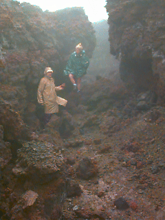
UH researchers Mike Garcia, Ken Rubin, and Kirsten Swanson
noted the existence of
a number of large fissures and cracks within the cone edifice during a recent
rock sampling trip to collect metamorphosed material from the cone. These
rocks will help us
to investigate whether or not this material could be assimilated back into
fresh Pu`u `O`o lavas, thereby altering their composition.
One of these fissures was more than adequate to
provide shelter from the driving rain of late March during their visit,
while also providing modest amounts of heat.
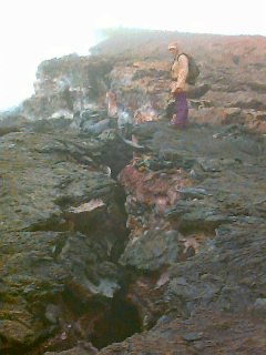
|
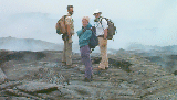
In the image above, HVO Staff Scientist Dave Sherrod (left)
shows Mike and Kirsten the
volcanic fume filled access to a near-Pu`u `O`o lava tube skylite during
one of his weekly visits to the vent on 26 Mar. Dave is studying cracks and
fissures at Pu`u `O`o.
|
Images from Kilauea taken on Mar 27, 1998 by Ken Rubin
|
|
Examples of deep fissures in the unstable Pu`u `O`o cone,
which is composed of tephra and lava flows. These features, along with
colapse pits in the cone flanks (see entry for 6 Dec. 1997 below),
indicate that the cone is breaking down and that constructive
processes are not keeping pace with destructive ones.
Today, the Kilauea East Rift Zone is mostly a flat, featureless
terrain (excluding a few craters) with only small constructional edifices at
old eruptive vents. Volcanologists are interested in knowing whether the lack
of features similar to the Pu`u `O`o cone at other Kilauea East Rift zone
vent sites indicates that they were once present but later eroded away or if
they never existed in the first place. The ongoing destruction of the
Pu`u `O`o cone, which began at an accelerated pace with a
major partial collapse
in January of 1997, gives support to the viewpoint that these features can
come and go over a period of years to decades during and after a rift zone
eruption at Kilauea.
|
|
|
A deep crater rim-parallel fissure
|
|
A deep crater rim-perpendicular fissure
|
5 - 16 Mar 1998
HVO reports that during this period, the Pu`u `O`o eruption has been
steady, with low
seismicity and low ground deformation at the Kilauea summit (due to
the "openness" of shallow magma conduits along the east rift zone, which
allow molten rock to flow without disturbing the ground surface). There were
brief outbreaks of surface flows on the Pulama pali (on 2 and 10 March - both
flows lasted less than a day) and on the coastal plain (small flows issued from
lava tubes on the coastal plain on 3 through 7, 10 and 14 March). Most of the
coastal plain breakouts have been near the Waha`ula ocean entry.
The Pu`u `O`o vent area has changed little over the last six weeks, except for
a new "glowing hole" in the Pu`u `O`o crater floor first observed on 11
March and a "glowing hole" from the crater vent (a pre-existing feature at
Pu`u `O`o). The latter has not produced any surface lava flows for more
than three Volcanic vapors are presently
issuing from the cone and surrounding area, sometimes so intensely
that little of the vent is visible even to helicopters.
24 Feb 1997 - 5 Dec 1997: LAVA EFFUSION AND THEN SEA ENTRY RESTART AFTER HIATUS, Pu'u O'o DISPLAYS SPECTACULAR CRATER OVERFLOWS
Happy 15th Birthday to Pu`u `O`o on 3 Jan 1998
Current eruption information for those
visiting Hawai`i Volcanoes National Park can be obtained from the
National Park Service at 808-985-6000 or at their web site:
Hawai`i Volcanoes
National Park. Also, visit the USGS Hawaii Volcano Obervatory we site at:
http://hvo.wr.usgs.gov/geology/update2.html.
Recent Images from Kilauea (click for enlargements)
Courtesy of NASA's
Virtually Hawaii project
|
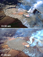
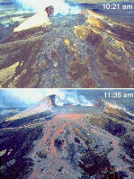
|
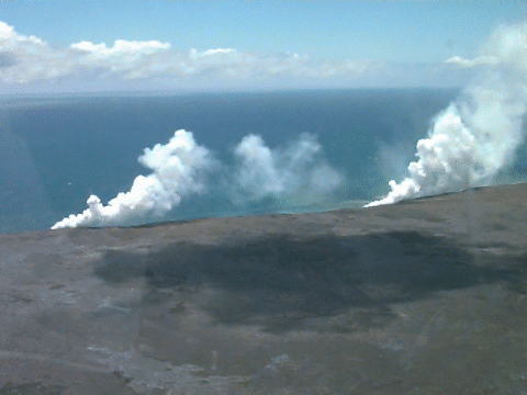
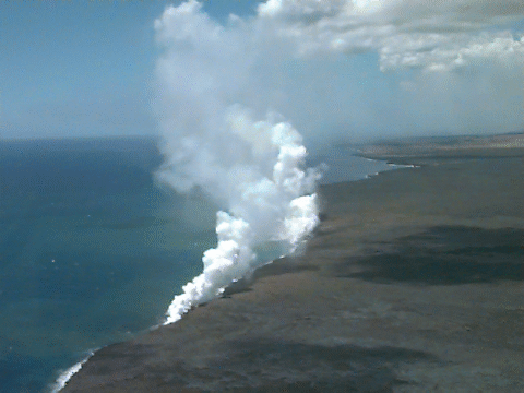
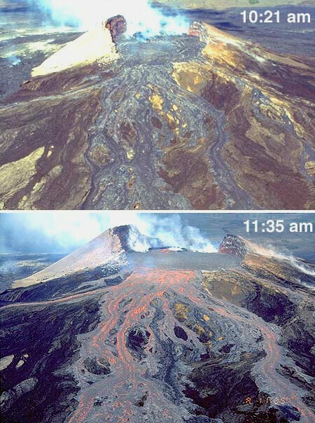
Two time sequences from above (left) and from the East side (right)
of Pu`u `O`o just before and during a recent overflow episode
on 6 Aug 1997. Both "before" shots show evidence of previous
recent lava spill-overs, although the more typical recent eruption
style has been for lava to exit from the crater in subterranean
lava tubes to feed smaller vents on the outside of the crater.
This time sequence spans just over an hour between 10:21 and 11:35 AM
|
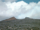
|
|
Over view of the Pu`u `O`o cone
|
|
Side view of the Pu`u `O`o cone
|
24 Nov - 5 Dec 1997
Visible eruptive activity within the Pu`u `O`o crater remains
light. However, HVO reports that loud "roars" have been recently heard
by visitors and residents near the volcano. These sounds have been
accompanied by occasional deposition of pyroclastic debris (bits of volcanic material that can be molten when injected into the air but that then solidify
before landing) up to 10 km away from the vents. Pele's hair, a thin
"string" of solidified lava an inch or so in length (in this case), is one of
the pyroclastic materilas being deposited. A particularly active period of
deposition occurred over the weekend of 28-30 November. These events
also show up in seismograms collected near the Pu`u `O`o vent.
HVO believes these roaring sounds and emmisions of volcanic
debris are due to the sudden escape of volcanic gasses building up in the
magma conduits beneath the volcano but they continue to investigate the
phenomenon.
HVO also reports that a small (0.65 acre) collapse of a
lava bench at the sea entry occurred on 24 Nov, It was smaller that
the collapse that occurred durring the first week of November (see below)
but was nontheless still a spectacular sight (from a distance).
16 - 23 Nov 1997
Activity within the Pu`u `O`o crater remains light,
with incandescent lava remaining entirely within the crater and being visible
only from the air.
On Nov 16, east Hawai`i (especially Hawai`i Volcanoes
National Park) were engulfed in one of the worst episodes of VOG ("volcanic
smog") for the year. Elevated VOG levels were even seen on the island
of O'ahu, some 330 km away. This particular episode arose from gentle
southeasterly winds blowing much of the sulfur dioxide (SO2)
emissions from Kilauea's east rift zone inland and produced air that
exceeded EPA (SO2) standards. The National Park Service
closed their Headquarters at the Kilauea summit that day.
4-15 Nov 1997
A lava bench collapse occurred durring the first week of
November, removing most (4.75 acres) of the episode-55 lava bench at East
Kamokuna, into the sea. No one was injured and no property was lost.
The collapse left a new sea cliff of a few meters in height and roughly 50 in length. Since that time the new lava flow has been filling an embayment
at the foot of these cliffs and slowly progressing seaward again.
Activity within the Pu`u `O`o crater has diminished
somewhat over the past couple of weeks following the more vigorous activity
of weeks past. Lava within the crater is visible only from the
air directly above the crater. The ocean entries are still active, however.
18 Oct-3 Nov 1997
Another episode of crater overflow occurred at Pu`u `O`o on
the 18th through 19th of October, beginning at early in the AM (0400 HST).
As in previous overflows of the past few months, lava ponded within the
crater and then flowed out through low points on the east and west rims of
the crater. As of the evening of the 19th, the pond was draining efficiently,
keeping pace with the vigorous crater eruption. These overlow events create
broad areas of incandescent lava resulting in what HVO describes as a
"spectacular orange glow in the night sky surrounding Pu`u `O`o". This glow
has recently been visible from up to 45 km away.
Lava that normally travels in tubes to the coast to feed the
ocean entries dwindled to a trickle at noon on Oct. 18 and the steam plumes at the entries disappeared for a brief while. Ocean entries resumed more
vigorously on the morning of the 19th.
Sept 28-Oct 3 1997
HVO reports that flows from the south shield vent (source of the flows
presently entering the ocean near the eastern boundary of Hawai`i
Volcanoes National Park) are moving within lava tubes for most of their length and are only visible through occasional skylights in the roof of the tube.
Two short-lived breakouts from this tube system occured on the coastal plain
during the last two weeks. The spatter cone at the vent on the Pu`u `O`o
crater floor consumed itself as it subsided into its own throat, leaving a pit that is about 40 m in diameter. This pit is the source of lava issuing into
the crater from below.
Also, a limited lava overflow of the Pu`u `O`o crater occured on 28 Sept., feeding
a small flow that "crept a few meters west of the rim and a few tens
of meters to the east". This event was less dramatic than the one pictured
above from 6 Aug but is nonetheless noteworthy.
Aug 17-Sept 23 1997
Kilauea's east rift zone eruption has settled into a regular pattern
of effusion over the past month: Lava erupts continuously inside
Pu`u `O`o crater from a spatter cone on the Pu`u `O`o crater floor.
It flows a short distance and then feeds a lava pond in the eastern part of
the crater or disappears through cracks in the crater floor. This is
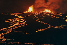
the pond that has occasionally risen until it spilled over the crater rim
(pictured near the top of this document). HVO reports that the last and most
voluminous overflow on August 6 produced pahoehoe flows that extended 1.2 km
to the northeast. They estimate relatively high recent eruption rates of
100,000 to 900,000 cubic meters per day.
Lava is also emanating from a small vent on the "South Shield" area just
outside the Pu`u `O`o cone. This lava feeds tubes that least to the coast.
Lava is still entering the sea at Waha`ula and 1 km to the west near
Kamokuna. Earthquake activity has been light during this past few weeks.
|
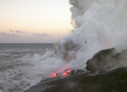
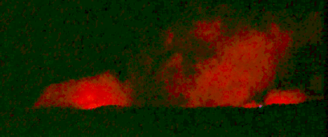
July 1997 Images from Kilauea (click for enlargements)
|
|
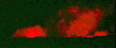
|
|
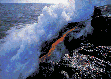
|
The sea entry at sunset
|
The glow of lava illuminates the steam
plume at the sea entry after dark
|
The Pu`u `O`o cone
|
Aug 11-16 1997 (all entries below this also dated 1997)
An important cultural and archaeological treasure was lost around
1 AM on the morning of the 11th as a lava flow overran Waha'ula,
a 700 year-old Hawaiian temple (heiau). The flow almost
completely obscured the rock walled structure, which was one of the
oldest Polynesian temples in Hawaii. The temple, thought to have been
built by the Tahitian priest Pa'ao in about the year 1200, had been spared
by earlier lava flows in the area in June-July 1989, December 1989 and
December 1990. It was an important religious site because it is believed
by many to be the first in Hawaii where human sacrifices were preformed.
More recently, it was used for worship by Kamehameha the
Great, who dedicated the temple to his war god Kuka'ilimoku during his
drive to unify the Hawaiian islands in the late 18th century.
Although this temple has been threatened by Pu'u O'o flows numerous
times in the past
14 ¾ years, it stood as a kipuka surrounded by lava (A kipuka is
an "island of old terrane surrounded by younger lava flows)
and had seemed immune to the destructive
forces of Pele (the Hawaiian Volcano Goddess). This same flow overran a
temporary access road to the Royal Gardens subdivision. No homes are
presently threatened.
A second crater "spill-over" event occured on 12 Aug, indicating that
the surge in activity at the vent on 6 Aug (see below) was not an isolated
incident.
Aug 4-10
Lava began flowing into the sea again on 4 Aug after having ceased on
29 July. The sea entry is still in a relatively remote area, 3 to 6 km
east of the end of the Chain of Craters road in the National Park.
Activity at the Pu'u O'o vent was continuous during this hiatus at the coast,
however. Additionally, HCV researcher Peter Mouganis-Mark and colleagues
reported observing from the air a spectacular lava "spill-over" out of the
Pu'u O'o cone on 6 Aug. This sent rapidly moving flows out of the
south-eastern side of the cone.
July 29 - Aug 2
On 29 July, the flow feeding the sea entry ceased when its
lava tube was clogged. Soon thereafter, a new flow was
initiated and began flowing down slope away from the vent.
The new flow was within 1 km of the coastline as of 1 Aug
and a new sea entry is anticipated soon.
July 19-28
Sea entry of lavas continues as it has since 12 July (see the photo above or
click here to see a larger version). Surface flow
activity on the coastal lava bench is extremely limited, with most flow
occurring in lava tubes that break out only right at the coast (a "lava tube"
is a lava pipe, formed when the immediate surface of a flow in a channel
cools such that molten lava is contained within the conduit).
Up at the Pu'u O'o vent, the lava shield surrounding the main cone
continues to expand, as do a few of the spatter cones ringing its
exterior on the southern side. As the shield grows, it has become
both thicker and has spread farther from the vent.

|
A lovely fern glen
that only a month prior was an excellent spot to enjoy lunch was burned
and partially covered by lava from the advancing flows.
|
July 12-18
Lava entered the sea again on 12 July for the first time since January.
The flow is approximately 500 meters wide, with many small lava rivulets
entering the sea and contributing to a large steam plume. The flow presently
poses no danger to people or structures but is it expands eastward,
it could harm Waha`ula Heiau, a 700-year-old, rock-walled structure
500 meters to the east of the current ocean entry. The flow could also reach
the four-wheel-drive access road for the Royal Gardens subdivision.
Meanwhile, lava from the crater cone inside the Pu`u `O`o crater has flowed strong enough that twice this month (between July 7 and 11) the level of lava
overtopped a gap in the west wall of the cone and overflowed out of it. These overflows lasted for less than hour and for several hours (respectively). They do not occur continuously because the crater cone is not always active and because the ponded flows inside the crater frequently drain through unseen conduits in the crater floor.
July 3-10
HVO reported today that a
lava flow is nearing the extreme southwest end of Royal Gardens
subdivision on the south flank of Kilauea. This is the first time lava has
flowed over Pulama pali onto the coastal flat since last January. The flow
is fed from a vent on the southwest flank of Pu`u `O`o. It was first
sighted above the pali on July 3 and was most of the way down the pali by
July 7. By this morning, the narrow flow had reached just beyond the
boundary of Hawaii Volcanoes National Park but may be turning southward and
could re-enter the Park between Kamoamoa and Waha`ula. At present the flow
front is 1 mile from the coastline at an elevation of about 120 feet. The
flow front is now in grassland, and fires are possible.
June 30
An earthquake shook the entire Island of Hawaii at about 0547 this morning.
The earthquake had an estimated magnitude of 5.3-5.5 and took
place within the south flank of Kilauea, about 6 miles south-southeast of
Pu`u `O`o, at a depth of about 4.5 miles. The earthquake was felt
throughout the island, but minor damage
was reported only in the southeastern part of the island. The
earthquake was located in the same area as the much larger, 7.1-magnitude
earthquake (the Kalapana earthquake) of November 29, 1975. Today's earthquake
caused no observable change in the ongoing eruption at Pu`u `O`o.
June 18-28
Flows are presently
confined to the general vicinity of the Puu Oo vent, helping to build
up the lava shield (the low bulge beneath the cone in the photo above) by
an additional 115 feet. Such a rapid buildup has not been seen since 1992.
Spectacular episodic fountaining, as seen in the
pictures above and in the 24-27 May entry below, has
resumed from a few of the spatter cones ringing the
southern outside edge of the Pu'u O'o cone. HVO and Hawaii Volcanoes
National Park report that this episodic activity can be viewed safely
from the Pu`u Huluhulu overlook, a 2.3-km (1.4 mi) walk from the Mauna
Ulu parking lot off Chain of Craters Road.
June 16-17
At 10 AM on the 16th, seismic tremors (earthquakes) and lava
spattering intensified within the Pu'u O'o Crater. By 2:30 PM, magma supply
to the vent had caused the crater to overflow, sending a large open
channel pahoehoe flow north. This activity lasted for 1.5 hours, followed
by a few hours of repose and a few more hours of eruption. As of 17 June
the vent area was quiet again.
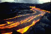
For those of you who don't know,
Pahoehoe is a type of lava flow formed when
lavas are particularly fluid and move rapidly over the landscape. At times,
the margins of the flow cool enough to channelize the flow, helping it
to move greater distances instead of dispersing in all directions,
such as in the picture on the right. This photo is from an earlier stage
of the Pu'u O'o eruption, when the cone itself was more regularly-shapped.
Although "Pahoehoe" is a Hawaiian word, it is used around the world to
describe these types of flows.
|
|
|
Much of the area around Pu'u O'o was covered in thick tropical forest
prior to the start of volcanic activity there in 1983.
Now, much of the area is barren. One of the
interesting features of the landscape when a lava flow overruns a forest are
lava tree molds. such as the one on the left (taken near Pu'u O'o).
As lava flows by the tree, it cools enough to solidify as it burns
away the tree's trunk. Lava further away continues to flow by, leaving
"forests" of these curious-looking statues.
|
June 2
HVO reports that several earthquakes (up to magnitude 3.5)
were felt by visitors, residents, and workers in the Namakani Paio campground
area of the Hawai`i Volcanoes National Park. In the first four hours of the
swarm 60 earthquakes were located from this source region.
The significance of these shallow (5 km) earthquakes is being studied but
they pose no danger to campers at this time.
It is not clear if
they are even directly-related to eruptions at Pu'u O'o. The HVO staff will
continue to monitor the activity and notify us of any new developments.
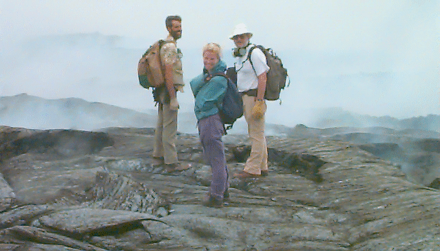
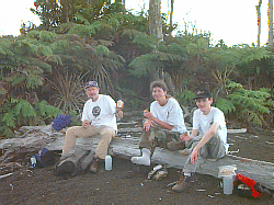
May 24-27
 |
Following the 23 May hiatus noted below, Pu'u O'o activity
resumed with spectacular fountaining from the episode 55 Spatter Cone,
followed by breif periods of quiessence. We had the opportunity to visit Pu'u O'o during this period, as did a number of other University of Hawaii
scientists. The picture to the right shows multiple flows arising from two
active vents on the south flank of the Pu'u O'o cone. This photo was taken
by Terry Kirby at about 2 AM on Monday 26 May. The lava fountain
is about 50 feet high |
May 10-23
Beginning on May 10 an continuing through May 15,
the eruption began pausing for periods of up to 10 hours. Then things resumed
to a more stady eruption rate. On 23 May, a pause
of 15 hours occured.
During these pauses, the seismic activity
(earthquake) recorded in the area was also diminished. Onsite video
(from HVO) and helicopter pilot reports indicated that lava supply was low.
In addition, a third small new vent apparently became active on May 12.
It lies midway between the "55 spatter cone" (a vent that became active
on 28 March) and the "uplift" vent (a vent that became active on 17 April).
April 18-May 9
The mid-elevation breakouts of earlier this month have
stopped moving downslope, although one of them came within 1 km of of
the steep slopes that descend from the Kilauea East Rift Zone down to
the sea. Although limited in extent, eruptive activity has remained fairly
constant through this period
April 11-15
Two flows have been
observed to be moving away from the vent area, one breaking out at
2310' elevation and one at 2260' elevation.
Puuoo Pond is now reported to have lava at ~60meters below
lowest point on rim (this is a significant increase relative to that of the past month or so). This flank vent is experiencing moderately high
spattering (3 to 7m high) into a perched pond that is overflowing into lower
collapse pits and feeding active flows largely confined to the local
area. Most of the lava volume
appears to be headed southward as of friday, but it difficult to judge
if there is also any significant westward advancement. The flow at
2310' elevation has advanced 2.5 km seaward to 2100' elev. but is
still relatively confined. The 2260' elev flow has continued to slowly
expand south- and westward, moving to between 2200 and 2100' elev.
This flow is making slow progress towards the pali and (possibly) the sea.
The HVO eruption
update page
is now on-line. Check it out for the latest info.
April 3
New observations today of the Pu`u O`o-Kupaianaha eruption
(relayed from helicopter tour pilots this AM) indicate that lava is flowing
from two breakouts in the tube system near the 2300-ft. elevation,
approximately 1 mile from the vent area. As of 1030 AM, surface flows are confined to the recent flow field and have moved to within a mile of the
top of Pulama Pali.
April 1
Field observations of the Pu`u `O`o-Kupaianaha eruption site revealed today
that lava has re-entered the old tube system near Pu`u `O`o. Lava was seen
moving through the tube down to an elevation of about 2400 ft. This site
is less than 0.5 miles from Pu`u `O`o and there is no indication of just
how far the lava will continue to flow, or whether it will break out of
the tube system onto the surface. HVO scientists think surface breakouts
are likely, however, because parts of the tube have probably become clogged
since the tube was last active in January.
This new activity is part of Episode 55, which began on February 24 when
lava appeared in the crater of Pu`u `O`o after 24 days of inactivity.
Mar 31
Starting at least as early as March 29, lava reappeared in a pit (in
the Episode 51 vent area) on the southwest flank of Pu`u `O`o. This is
the first indication in about 2 months that lava is once again not
confined to a pond in Pu`u `O`o crater.
As of mid-day on March 31, the new lava pad within the Episode 51 pit remains
active and lava is spattering and flowing
southward in the next depression to the south before disappearing
underground. Additionally, the Pu`u `O`o pond appeared somewhat higher than
its previous depth of about 120-130 m.
Unfortunately, surface lava flows are still not currently visible nor
have lava tubes leading away from Pu`u `O`o to the sea been re-occupied.
Feb 24-Mar 27
The newest phase of eruptive activity at Kilauea volcano (Episode 55 of
the Pu'u O'o eruption) started unceremoniously on 24 Feb with the appearance
of a small amount of molten lava deep within the Pu'u O'o crater.
It is only visible from above. Episode 55 comes after a 24 day-long
hiatus in eruptive activity at Kilauea. This hiatus in turn followed
a brief but spectacular fissure eruption (Episode 54) at
Napau Crater in late January 1997.
This last long hiatus had many volcano watchers presuming that the 14 year
long Pu'u O'o eruption was finally Pau (Pau in Hawaiian means over,
or finished). This is because long hiatuses have not occurred during
the last decade at Pu'u O'o (the last long one was in mid-1986, when
volcanism switched from episodic, 300-500m high, fire fountains of lava
to continuous effusion).
Visit our
LISTING of Puu Oo eruption episodes for a summary of previous activity and
links to previous eruption update pages (where available).
CREDITS and DISCLAIMER:
This synopsis was written by Ken Rubin and Mike Garcia using some
information kindly provided by the U.S.Geological Survey's Hawaii Volcano
Observatory (in the form of formal press releases, personal communications
and information from their HVO
web site).
The US Geological Survey-Hawaiian Volcano Observatory is not directly responsible for
editorial changes or enhancements made by the HCV (the Hawaii Center for
Volcanology) web staff, nor does it claim responsiblity in any way for the interpretive content of these pages.
This page created and maintained by
Ken Rubin©,
krubin@soest.hawaii.edu
Other credits for this web site.
Last page update on 7 Jan 2008


