
Active Volcanoes and Associated Hazards in the Goma Area, Eastern Zaire
Jack Lockwood & Tom Casadevall
Active Volcanoes and Associated Hazards in the Goma Area, Eastern Zaire
Jack Lockwood & Tom Casadevall
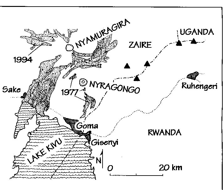
Figure 1. Sketch map of the southern Virunga volcanics, showing major towns (cross-hatched), historic lavas, (stippled), roads (dotted). Triangles are other Virunga volcanoes (see SIR-C image next article). Simplified from Tuttle et al. (1990), USGS Open File Report 90-691.
This article is excerpted from a report to the USAID Office of Foreign Disaster Assistance. In mid-July, 1994, when news reports indicated an influx of ~1.25 million Rwandan refugees into eastern Zaire, an informal call from the USGS to the State Department alerted the Central African Desk Officer to the potential volcanic hazards of this area, and the Office of Foreign Disaster Assistance (OFDA) was contacted on July 20. An OFDA-supported visit to Rwanda and Zaire by USGS geologists in 1989 had resulted in a regional hazards evaluation, which proved most useful in early planning by several relief agencies. The specific hazards addressed during the 1994 visit were the threat of active lava flows to resettlement camps and infrastructure, the threat of volcanic ash to air relief operations, and the threat of CO2 accumulation.
The Goma area of eastern Zaire lies entirely within the western branch of the East African Rift Zone (EARZ). The Virunga Volcanic Field (Fig. 1) extends from northern Rwanda into eastern Zaire. An ancient tributary of the Nile used to flow north along this part of the EARZ. Growth of Nyiragongo and Nyamuragira volcanoes dammed this tributary, formed Lake Kivu, and directed local drainage eventually to the Indian Ocean.
The principal volcanic hazards in this area are Mazukus, lava flows, volcanic ash, phreatomagmatic eruptions, earthquakes, and catastrophic degassing of Lake Kivu. Mazukus ("evil winds" in Swahili) are low-lying locations with dry CO2 vents. This hazard can be mitigated by identifying and preventing access to areas prone to gas accumulation. Nyiragongo and Nyamuragira are characterized by very fluid, low-silica lava flows. The 1977 Nyiragongo eruption occurred under relatively unusual circumstances (the rapid draining of a deep lava lake), however, the flows traveled 20 km in <1/2 hour, killing 70 (perhaps 500) people. Careful mapping and monitoring of the lava lake will help to mitigate this hazard. Nyamuragira has more gradual slopes and its flows probably don't pose a hazard to anything other than structures. Although not particularly explosive, basaltic ash (such as Pele's hair) is produced by Nyamuragira and Nyiragongo. It is irritating to humans but potentially fatal to cattle. Additionally, the ash can be a hazard to aircraft. The high water table around Lake Kivu provides the possibility of phreatomagmatic eruptions. In these cases, the eruptions are quite explosive and dangerous. Careful seismic monitoring might foretell an eruption in areas where magma-groundwater (or lake water)-interactions might occur. As in all volcanic areas, earthquakes pose a potential hazard that can mainly be mitigated by education and good building practices. Lake Kivu contains vast quantities of dissolved CO2 and CH4. Only a major landslide, eruption into or within the lake, or other large disturbance would be able to trigger catastrophic degassing of deep waters. Although this hazard is remote, it possesses the potential to cause the most fatalities.
The 1994 Nyamuragira eruption took place between July 4 and 17 within the summit crater and on the western flank. Lava fountains were several hundred meters high, and produced a line of cinder cones and a blocky lava flow about 10 km long. The only casualties were cattle who ingested large amounts of Pele's hair. The 1994 Nyiragongo eruption was confined to the summit caldera, and was preceded by ~4 years of increased seismicity. At least 6 short-lived eruptions have occurred since June 23. They have consisted of low fountaining on the floor of the caldera, perhaps indicating mostly the recycling of lava left over from the 1982 eruption, although new lava is presumably also being added.
There are two things that can help reduce the volcanic hazard in the short term: 1) modernization of the seismic network in the Goma area (including adding telemetry to a central seismic-interpretation station); and 2) regular monitoring of Nyiragongo activity, which is not always obvious from below. An international meeting to coordinate these efforts is tentatively planned for the spring of 1995 in Goma.
This effort was truly international and we would like to acknowledge fellow volcanologists from Zaire, France, and Japan: Ndontoni Zana, Muderhwa Nshombo, Kalendi Kavotha, Jacques Durieux, Jean-Louis Cheminee, Jacques Dagain, Hiroyiki Hamaguchi, and Hiroshi Ishii.
reprinted from the Hawaii Center for Volcanology Newsletter, Volume 2, Number 1, December 1994
 Hawaii Center for Volcanology Home Page
This page created and maintained by
Ken Rubin ©,
krubin@soest.hawaii.edu
Other
Last page update on 31 Jan 2002