
Loihi Volcano

INITIAL 1996 EVENT RESPONSE
Preliminary Science Report - LOIHI Rapid Response Team
Visit these Recent Activity Links Too:
Read a Haitian Creole translation of this web page by Susan Basen.
8/19/96
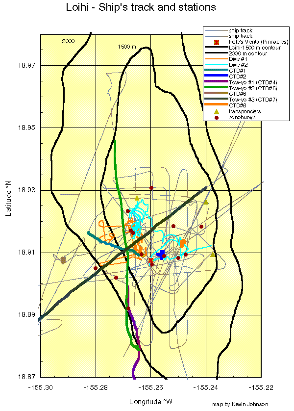
CLICK HERE TO VIEW THE SHIP
TRACKS OVER LOIHI DURING THIS EXPEDITION (the image has been left in
large format to retain details)
8/14/96
Preliminary Science Report Contents:
- Seismic Studies
- Bathymetric Studies
- Shipboard Water Sampling
- Water Chemistry
- Microbiological Studies
- Submersible Dives
- Rock Sampling
- Scientific Party, Affiliations, and E-mail Addresses
- Affiliate Scientists
- Acknowledgements
By: Frank Sansone, Fred Duennebier, and the Scientific Party

 An interdisciplinary team of researchers from the University of Hawaii has
completed an initial study of the immediate effects of an ongoing
underwater volcanic event at Loihi Seamount,  20 miles southeast of the
Island of Hawaii.  These researchers,  in collaboration with scientists
from the U.S. Geological Survey,  the Bishop Museum,  and the University of
Washington,  conducted a rapid response mission on the research ship R/V
Kaimikai O Kanaloa.  The ship is owned by the University of Hawaii and
operated by the Hawaii Undersea Research Laboratory (one of NOAA's National
Undersea Research Centers).
The research cruise, sponsored by the U.S. National Science Foundation,
departed August 5, and returned to Honolulu on August 10 after spending
four days at the volcano.  The preliminary findings of the research team
are outlined below.

Seismic Studies   (Fred Duennebier,  Nathan Becker)

An over-the-side hydrophone and 24 sonobuoys were deployed to record
seismic events in the summit region of Loihi.  Sonobuoys are underwater
microphones (hydrophones) connected to a free-floating buoy that radios
signals from the hydrophone back to the ship.  The over-the-side hydrophone
was not used routinely,  as its signals were swamped by ship noises.  A
variety of high frequency crackling and grinding noises,  which were likely
sounds of an eruption in progress,  were recorded from the summit area,
particularly in the area north of East Pit.  In contrast,  the southern
flank of the seamount was seismically quiet.  In addition,  time-of-arrival
information from sonobuoys released during a south-to-north tow-yo survey
indicated the summit to be the source of these sounds.
Many  events were recorded on two buoys at once.  Recording on more than
two buoys was not common,  as the strong currents tended to float the buoys
off the summit area within two hours of being deployed.  Digital recordings
of many events located on two buoys will be used to triangulate on the
source region,  and hopefully localize the site of the suspected eruptive
activity.
Large amplitude, low frequency signals corresponding to earthquakes
detected independently by the HVO seismic array,  were felt by personnel on
the ship during the first day of operations.  These events had magnitudes
of between three and four according to records at the Hawaiian Volcano
Observatory.  During the largest event,  acoustic communication with all
but one of the four permanent transponders on the ocean floor was disrupted
for more than 20 minutes,  recovering slowly to normal.  We hypothesize
that CO2 saturated water near the bottom released bubbles as a result of
this shaking,  and the bubbles attenuated the sound from these 12-16 KHz
transducers.  No earthquakes were felt after the first day.  While the
Pisces submersible was diving,  many sounds thought to be associated with
eruptive activity were recorded by sonobuoys,  but the sub crews reported
hearing no unusual sounds on the sub.
During the first submersible dive,  an ocean bottom seismometer was
deployed at "Pisces peak".  This seismometer should record data
continuously for the next three weeks and be picked up during dives in late
September.  Data from this seismometer should help to constrain event
locations recorded by the HVO by supplying an arrival time for many events
close to the source region.


Bathymetric Studies  (John Smith)

Multiple SeaBeam lines were run over the summit of Loihi.  Although the
multibeam data were of poor quality,  analysis of narrow beam bathymetric
data show significant changes in the summit geomorphology.  Former high
points,  such as Pele's Vents (formerly rising to 980 m), have been
replaced by pit craters hundreds of meters deep.  Pele's Pit now occupies
the former vent area,  with a width of 260 m and a depth of 300 m.
Combined submersible dive and bathymetric surveys suggest that besides new
pit craters,  several of the former small and large pits (East & West Pit
and the Thousand Fingers depression) have collapsed and coalesced into a
larger summit caldera which may still be forming.  Portions of the West Pit
rim are still intact while other parts have fallen away.  Several of the
existing pits appear to have deepened significantly.  This method of
caldera formation is evident on subaerial Hawaiian shield volcanoes such as
Kilauea.

Shipboard Water Sampling  (Brian Midson,  Frank Sansone)

The water currents in the Loihi area are generally from the ENE to the WSW.
Consequently,  we ran three tow-yo sections:  one,  7 km long, running S
to N just west of the main north-south ridge axis;  a second,  5 km long,
running WSW to ENE (parallel to the current) over the summit of the
seamount;  and a third,  1.6 km long,  running SW to NW just west of the
summit.  In addition,  5 hydrocasts were conducted,  primarily into the pit
craters at the summit.
Hydrothermal fluids apparently are accumulating in the bottoms of the pit
craters,  as evidenced by sharp vertical temperature and salinity gradients
in the CTD data,  and the high particle loading in the bottom waters.  The
pits show inverse density profiles (the bottom water less dense than the
overlying sea water) when using density values calculated from temperature
and salinity data.  This suggests that very high levels of particulate
matter or some chemical constituent such as CO2 is causing the bottom
waters to have greater density than indicated strictly from temperature and
salinity relationships.
CTD-measured anomalies of up to 3.5 deg C and 0.65 psu salinity were
measured in the water column within the bottoms of the pit craters, with
the largest anomaly in the new pit crater at the former site of Pele's
Vents.  Temperature anomalies of 0.5 deg C were commonly found in the water
column around the summit area.  Temperature anomalies of 0.1 deg C were
recorded during tow-yos at distances >4 km downstream of the summit.
The composition of the hydrothermal fluids appears to vary at different
venting sites,  as plumes and pit waters at different locations with
elevated temperatures have either negative or positive salinity anomalies.
This suggestion of phase separation (high salinity in water being boiled,
and low salinity in steam condensates) in the vent fluids will be
corroborated with other chemical data being collected.
The spatial distribution of the water column plumes suggests that there is
venting outside of the pit craters,  most likely in the area immediately
north of the East Pit.  This hypothesis is supported by visual observations
during the submersible dives of highly turbid water coming from this area,
and the collection of glassy rock fragments on the rosette when it was
inadvertently dropped on the seafloor in this area during the last tow-yo.

Water Chemistry  (Frank Sansone,  Joe Resing,  Brian Midson,  Terri Rust,
Betsy McLaughlin,  Irena Kolotyrkina,  Jim Gharib,  John Lupton*,  Eric
DeCarlo*,  Dick Feely*)

The water chemistry program had two goals:  (1) mapping of the extent,
intensity and chemical composition of the altered sea water in hydrothermal
plumes,  and (2) detailed characterization of the hydrothermal vent fluids
being released.  In particular,  we aimed to look for chemical markers that
may be indicative of underwater lava extrusions and early stages of hot
spot hydrothermal venting.
Plume water samples were collected in Niskin bottles during tow-yo and
conventional hydrocasts.  Proximal plume samples were also collected with
Niskins mounted on Pisces V during dives.  We also had titanium majors and
gas-tight samplers for vent fluid sampling during dives,  but we were not
able to locate any active vents.
Water samples collected from above the seamount contain extremely high
levels of suspended particles and chemical tracers apparently originating
from an eruption,  and show temperature anomalies which place them among
the most volcanically altered sea water ever recorded from an undersea
hydrothermal system.  Water samples collected from some of the hydrothermal
plumes are colored brown from the suspended particle load.
The Loihi plumes sampled are very acidic.  We measured pH values as low as
5.6 in plume samples from Pele's Pit that had temperature anomalies of
approximately 3.0 deg C.  These samples also had alkalinities as high as
3.15 meq/l,  implying a TCO2 concentration of > 9 mM (roughly 4 times the
concentration in sea water).  Sulfide values are not available yet,  but
none of the plume waters recovered had a detectable sulfide smell.
Dissolved gas analyses include methane and methane carbon stable isotopes,
hydrogen, helium isotopes and (dissolved inorganic carbon) (DIC) and DIC
stable carbon isotopes.  DIC is of particular interest at Loihi because its
vent fluids have previously been shown to be very enriched in DIC;  samples
collected on this cruise from the warmest plumes have been noticeably
gassy.  The results of all these measurements will not be available until
after shore based analyses are complete.
Dissolved Fe and Mn levels in the plumes were also very high.  Shipboard
analyses indicate maximum Mn levels of 0.4 uM in the plumes and 5.5 uM in
Pele's Pit.
Filters from the hydrocasts were clogged with particulates,  at least some
of which (2nd CTD) are clay particles.  Shipboard analyses for Al showed
unfiltered pit water concentrations an order of magnitude greater than
those for background sea water.  After acidification,  repeated analyses of
these samples showed concentrations of Al increasing continuously over
time,  suggesting dissolution of suspended particulate material.  The
mineralogy of suspended particles will be determined by X-ray diffraction
and their chemistry by X-ray fluorescence (in particular, P, V, and As).
Water samples will also be analyzed for inorganic nutrients by
AutoAnalyzer.  In addition members of the team will make low-level
fluorescent measurements of dissolved ammonia and analyze for the following
dissolved chemical species in the plume waters:  Cu, Zn, Cd, P, V, As, Ti,
and rare earth elements.

Microbiological Studies (Xiyuan Wen,  Betsy McLaughlin,  Jim Cowen*,  Marv
Lilley* )

Measurements of methane oxidation rates and methane oxidation isotopic
fractionation in plume samples are being conducted.  Plume and background
water samples were collected for determination of total bacteria numbers
(epifluorescene and flow cytometry) as well as measurements of biomass
(LPS).  Visual observations of TEM (tunneling electron microscope) and SEM
(scanning electron microscope) samples indicate that there is a tremendous
number of suspended particles in the plume water.  Variations in numbers of
bacterial functional subpopulations will be measured using morphotype
indicators by a combination of analytical transmission electron microscopy
and fluorescence microscopy.
Microbial methane and hydrogen oxidation rates in the plume waters are
being measured.  Plume water samples were preserved for DNA extractions so
that preliminary estimates of the diversity of the microbial community can
be obtained utilizing molecular biological techniques.  Both aerobic and
anaerobic media were inoculated with plume fluid samples to obtain
microbial cultures for further investigation under laboratory conditions.

Submersible Dives

Scientists dove to the summit of Loihi seamount on Thursday, August 7, in
the Pisces V manned submersible to study first hand the effects of the
seismo-volcanic event (Dive P - 286).  The sub landed near the highest
point of the seamount (Pisces Peak) and worked its way slowly south towards
the new pit crater through murky waters, with visibility less than 5 feet
at times.
Most of Loihi's surface consists of large broken boulders and parts of
basaltic pillows.  Several areas along the 2 mile route displayed fresh
surfaces with newly broken pillows uncovered by large landslides or by
shaking,  likely due to recent earthquakes.  Older surfaces are light brown
while fresh surfaces are nearly black.
While traversing the edge of West Pit,  a previously existing pit crater on
the western side of the summit,  several glassy fist-sized rocks were
recovered that had been thrown out of the crater together with glassy black
sand grading to coarser material as the crater was approached.  As this
deposit is very thin and present only in a few areas, it may be the result
of a landslide on the other side of West Pit that threw debris across the
crater and onto the opposite rim.  The freshest glassy rock samples were
obtained from this crater rim.
A visit to Pele's Pit, the new pit crater detected by shipboard sonar,
showed that it is indeed there,  and that the Pele's Vents area was
destroyed by this crater-forming event.  The pit is nearly filled with a
cloud of murky water.  West Pit,  to the north of Pele's Pit,  has been
enlarged considerably by this activity and now connects with Pele's Pit.
As the current washes across the summit from the northeast,  the "smoke" in
the water was believed to come from either west pit or east pit.  The smoke
is milky in some areas,  while obviously particulate in others with
cohesive globs of material.
Black sand,  indicative of relatively violent eruptive activity is present
in patches,  as is a fine white sandy material.  The white material may be
associated with the flox particulates in the water,  and is likely to be
bacterial in origin,  although no samples were obtained of this material
from the ocean floor.  In places the white sand fills the cracks in rocks,
much like a fine dusting of snow.

A second dive on Friday, August 9  (Dive P - 287) also began near Pisces
Peak,  but then headed north along the northwestern rim of West Pit in an
attempt to skirt the turbid water coming from the ENE.  However, visibility
remained poor,  so after several hours the sub was flown across West Pit
above the murky water to the NW rim of East Pit (visibility cleared at an
altitude of only a few 10's of meters above the rim of the pit).  The sub
then descended into East Pit to collect a large number of water samples of
the hydrothermally altered bottom water.  The water deep in the pit was
approximately three degrees warmer than normal.

Rock Sampling

Six volcanic rocks were collected on the first dive (Dive 286) and one rock
was collected on the second dive (Dive P - 287).  The rocks from Dive 286
include a very fresh sheet flow fragment with 2-3 cm thick glass rind
(P286-1),  several fresh,  glassy pillow lobes and toes,  and a
hydrothermally altered glass-free flow fragment (P286-2).  Based on its
extremely fresh glass and its brittle,  friable texture,  P286-1 is judged
to be the youngest sample collected.  Two other samples,  P286-5 and
P286-6,  contain slight hydrothermal coatings on fracture surfaces,  but
are otherwise quite fresh with 0.2-0.7 cm glassy rinds and sparse olivine
phenocrysts.  Sample P286-3 is a very fresh,  glassy bud with up to 0.1mm
glass,  and little or no alteration.  Sample P286-4 is a 5cm rock fragment
with sparse glass and minor alteration.
Preliminary analyses (Garcia)  of the freshest samples show that they are
tholeiites similar in composition to other Loihi tholeiites,  as opposed to
more alkalic rocks found on the deeper slopes of Loihi.

The single rock sample from Dive 287 (P287-1) is a 4 kg pillow fragment
with orange hydrothermal coating.  Under the hydrothermal coating is a
layer of reasonably fresh glass.  A "scoop sample" of black sand-to-gravel
size material was also collected (P287-2);  this sample consists of freshly
broken rock fragments and basaltic glass,  with a small amount of
hydrothermal clays and altered rock.

In addition,  several small glassy rock fragments were collected during the
last tow-yo hydrocast imbedded in the lead at the bottom of the CTD frame.

________________________________________________________________________

Scientific Party, Affiliations, and E-mail Addresses

Fred Duennebier (Chief Scientist) - Univ. Hawaii - fred@soest.hawaii.edu

Frank Sansone (Co-chief Scientist) - Univ. Hawaii - sansone@soest.hawaii.edu

Nathan Becker - Univ. Hawaii - nbecker@soest.hawaii.edu

Jim Gharib - Univ. Hawaii - jgharib@soest.hawaii.edu

Chuck Holloway - NOAA/Univ. Hawaii - holloway@soest.hawaii.edu

Kevin Johnson - Bishop Museum/Univ. Hawaii - kevinj@soest.hawaii.edu

Kevin Kelly - Univ. Hawaii - kevink@soest.hawaii.edu

Irena Kolotyrkina - Univ. Hawaii - c/o malahoff@soest.hawaii.edu

Betsy McLaughlin - Univ. Washington - betsy@ocean.washington.edu

Brian Midson - Univ. Hawaii - bmidson@soest.hawaii.edu

Joe Resing - Univ. Hawaii - jresing@soest.hawaii.edu

Jennifer Reynolds - USGS/Hawaiian Volcano Observatory - jrr@tako.wr.usgs.gov

Terri Rust - Univ. Hawaii - trust@soest.hawaii.edu

John Smith - Univ. Hawaii - jrsmith@soest.hawaii.edu

Xiyuan Wen - Univ. Hawaii - xwen@soest.hawaii.edu

Affiliate Scientists:

Alex Malahoff (UH)
Marv Lilley (Univ. Washington)
John Lupton (NOAA/PMEL)
Jim Cowen (UH)
Eric DeCarlo (UH)
Ken Rubin (UH)
Mike Garcia (UH)
Rodey Batiza (UH)
Paul Okubo (USGS - HVO)

Acknowledgements:

The Science Party wishes to thank all who helped make this cruise possible
by responding so quickly and positively to this initiative.  In particular,
the many scientists who helped write the proposal,  the SOEST and
University administration for extremely rapid processing of the proposal,
and the National Science Foundation  for their nearly instantaneous review
and decision.
The HURL Pisces submersible crew,  led by Terry Kerby,  operated
flawlessly,  and the crew of the Kaimikai O Kanaloa,  headed by Capt. Bob
Hayes,  helped at every step to make this cruise a success.
 Return to the Hawaii Center for Volcanology LOIHI Page
 Return to the Hawaii Center for Volcanology Home Page
This page created and maintained by
Ken Rubin©,
krubin@soest.hawaii.edu
Other credits for this web site.
Last page update on 25 February 1997
